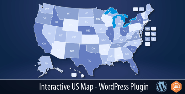
When you need to present state-specific data, office locations, service areas, or any information tied to geography, a static list of links simply won’t cut it. The Interactive US Map – WordPress Plugin by Art101 solves this by delivering a polished, professional map of all 50 states plus Washington D.C., where every single state is a clickable hotspot. With over 4,000 sales on CodeCanyon, this plugin has become a trusted utility for website owners who want to turn a simple visual into a powerful navigation and information tool. Whether you are a national retailer, a political blogger, or a web developer building a client site, this plugin provides the easiest route from a blank page to a fully functional, interactive map without writing a single line of JavaScript.
Key Features
The Interactive US Map – WordPress Plugin is packed with practical features designed to save time and deliver a seamless user experience. Here is what you get right out of the box:
- 50 Clickable States plus D.C.: The map is fully interactive, allowing visitors to click any state to trigger a custom action, such as navigating to a page or opening a popup.
- Simple Shortcode Integration: After installation and customization, you insert a simple shortcode like
[us_map]into any post, page, or widget area to display the map instantly. - Multiple Maps on One Page: Starting with version 2.4, you can use more than one map on the same page. By using distinct shortcodes like
[us_map]and[us_map_ii], you can differentiate your maps and assign unique data to each. - Bulk Edit Option: Managing 51 states manually would be tedious. The bulk edit feature allows you to update hover information, tooltips, and links across multiple states at once, saving significant administrative time.
- 3rd Party Popup Plugin Integration: The plugin includes an option to integrate with popup builders like Popup Maker (free version). This allows you to open a modal window for each state, making it perfect for displaying regional details without leaving the page.
- Customizable Hover Tooltips: You have full control over the hover text appearance. The changelog indicates options to choose the color of state abbreviations on hover and control the opacity of inactive states, ensuring the map matches your site’s branding.
- Toggle Optional Geographic Elements: Depending on your use case, you can hide or show specific elements. Version 2.6 introduced checkboxes to hide lakes, Alaska, Hawaii, and D.C., giving you layout flexibility.
- Touch Device Optimized: The plugin script has been updated to fix scrolling issues on touch devices, ensuring that mobile and tablet users can interact with the map just as effectively as desktop users.
Who Is This For? Use Cases
The versatility of this map plugin makes it suitable for a wide range of industries and project types. Below are the most common scenarios where the Interactive US Map – WordPress Plugin proves invaluable.
National Brands and Franchises
If your business operates in multiple states, you likely have a “Locations” page. Instead of a simple drop-down list, use this map to let customers click their home state to see local contact information, store hours, or specific offers. The integration with popup plugins is particularly useful here—a visitor can click “Texas” and see the Dallas, Austin, and Houston branches pop up instantly, keeping them on the page and reducing bounce rates.
News Portals and Political Sites
Election season or not, news sites often need to display state-specific data. Whether you are showing electoral votes, poll results, or legislative updates, the ability to hide Alaska, Hawaii, and D.C. (via the checkbox option) lets you focus on the continental U.S. when necessary. The hover tooltips can display key statistics, while clicks can lead to category archives for that specific state.
E-commerce and Multi-Region Retailers
If you sell products with state-specific availability (e.g., shipping restrictions or regional pricing), the map acts as a visual filter. You can link each state to a filtered product category or a dedicated landing page. The “Bulk Edit” feature is a lifesaver here, allowing you to assign the same link format to multiple states without repetitive input.
Real Estate and Service Professionals
Realtors, contractors, and home service providers can use the Interactive US Map – WordPress Plugin to showcase their coverage areas. Clicking a state could open a modal with the agent’s contact info for that region or link to a list of available properties. The lightweight SVG graphics ensure the map does not slow down your page, keeping your Core Web Vitals in check.
Web Developers and Agencies
Since the plugin is built for WordPress and works seamlessly with the Gutenberg editor, developers can include it in client projects without steep learning curves. The option to install multiple instances (the plugin comes with 3 installable copies) means you can use it on development sites first without disturbing the live version. This is a practical testing feature that reduces risk during updates.
Technical Details & Compatibility
Understanding the technical foundation of a plugin is critical before making a purchase. The Interactive US Map – WordPress Plugin is built on SVG (Scalable Vector Graphics), ensuring crisp rendering on high-resolution displays and smooth scaling across different screen sizes. Here are the key technical points:
- WordPress Compatibility: The plugin is designed for modern WordPress versions. The description notes compatibility with WordPress 7.0.2, indicating that the developer is actively maintaining the plugin to keep pace with core updates.
- Gutenberg Ready: The tags clearly list Gutenberg, confirming the plugin works within the modern block editor environment without requiring a Classic Editor fallback.
- Shortcode System: The plugin uses a simple shortcode (
[us_map]) for deployment. The inclusion of multiple map instances ([us_map_ii]) allows for complex page layouts. - Frequent Updates: The changelog shows consistent updates from 2015 through March 2023, demonstrating long-term support. The most recent version (V2.7) added hover color options for abbreviations and opacity adjustments for inactive states.
- Frontend Loading Optimization: Version 2.4 introduced a feature that hides the map until it is fully loaded. This prevents ugly layout shifts and ensures a smoother user interaction.
- Libraries and Dependencies: While the plugin relies on an SVG mapping tool, it does not require any external API keys or paid services. This means no recurring fees or third-party tracking.
It is worth noting that the plugin does not come with a page-builder style interface; instead, it uses a dedicated dashboard for customization. This dashboard was enhanced in v2.4, making the backend experience cleaner and more intuitive.
Pros and Cons
To give you a transparent view, here are the strengths and potential drawbacks of the Interactive US Map – WordPress Plugin, based solely on the provided documentation.
Pros
- Proven Track Record: With 4,068 sales on CodeCanyon, this is a battle-tested plugin with a substantial user base. Popularity often correlates with reliable support and fewer bugs.
- Active Development: The update history from 2015 to 2023 shows the developer is responsive to WordPress core changes and user feedback. This is a critical factor for long-term site maintenance.
- Popup Integration: The ability to pair with Popup Maker expands the plugin’s functionality far beyond a simple link map. It turns the map into a dynamic info hub.
- Bulk Editing: Managing twenty or thirty states efficiently is a feature that competitors often lack. This saves hours of admin time.
- Mobile Friendly: The explicit fix for touch devices ensures the map works on modern smartphones and tablets, where a large portion of web traffic originates.
Cons
- U.S. Only: This plugin is specifically for the United States. If you need a world map or a map of another country, this tool will not fit your needs.
- Update Process Complexity: The changelog notes that older updates (specifically v2.2.0) required full removal and reinstall of the plugin. While this was fixed in later versions, users should be cautious when upgrading from very old versions.
- Requires Manual Popup Setup: While integration with 3rd party popup plugins is a plus, it also means you need to install and configure a separate popup plugin if you want that feature. It is not a built-in modal editor.
Frequently Asked Questions
Before you commit to a purchase, here are the answers to common questions that shoppers have about this specific utility.
Is the Interactive US Map WordPress Plugin compatible with the latest version of WordPress?
Yes. The plugin’s tags explicitly mention compatibility with WordPress 7.0.2. The developer, Art101, has a history of updating the plugin to align with core WordPress releases, as evidenced by the March 2023 update (V2.7). Since the coding standards are maintained and Gutenberg is supported, you can safely use it on a current, up-to-date WordPress installation.
Can I use the plugin with WooCommerce or other e-commerce systems?
While the plugin does not have an official WooCommerce integration listed, it is a standard WordPress plugin that outputs shortcodes. This means you can place the map on a WooCommerce landing page or product category page. You can link each state to a specific product category URL, making it work as a visual navigational aid. The plugin does not require any special permissions, so it will not conflict with WooCommerce’s standard hooks and scripts.
Does the plugin include support and how easy is it to update?
Yes, the plugin comes with the standard CodeCanyon support policy, and the description explicitly states that you can contact the developer directly for help: “At any time, if you have any issue or need any help, please contact us and we will be more than happy to help you.” Updates are handled by downloading the latest zip file from your downloads page. You can either upload and replace the plugin via the WordPress admin or use sFTP.